Theme
Knowledge base
How Augmented Reality & Artificial Intelligence Are Ushering in Next Gen Navigation
3 min
How Augmented Reality & Artificial Intelligence Are Ushering in Next Gen Navigation
The two powerful technologies can deliver massive navigational benefits for drivers and branding opportunities for OEMS – but only when nav solutions allow AI and AR to work together seamlessly.
NNG
28 Sep, 2023
The era of autonomous vehicles is potentially just round the corner. It will give us the ability to let our vehicles drive us to our destinations as well as enjoy routing that improves traffic flows, plus reduce pollution and energy usage in the process. While questions remain about the delivery of fully Connected and Automated Vehicles, key elements of their technology are already changing how we will use and benefit from next gen navigation solutions in the future.
Currently, the driver enters their desired destination into their IVI, which in turn creates an optimized route. However, the next generation of navigation is introducing deeper, more meaningful uses of artificial intelligence (AI) combined with the latest in augmented reality (AR). Combined, these offer rich opportunities for both vehicle users and OEMs including:
Creating safer driving experiences
Help drivers to manage complex driving situations including unmarked lanes and intersections plus hard-to-navigate highway interchanges.
Increasing situational awareness
Keep drivers focused on the road ahead by eliminating distractions via intuitive, flexible HUD and UI options.
Enhancing brand experiences
Enable OEMs to create unique immersive brand experiences that stand apart from traditional built-in/brought-in navigation solutions – when partnered with the right navigation partner (see below).
Delivering on the potential
To deliver such great benefits, three ‘building blocks’ are required – enriched Standard Definition (SD) and High Definition (HD) maps, highly accurate 6D localization modeling, and the deployment of powerful, driver-friendly AR technology:
Defining maps
Existing navigation needs are already being met by SD maps. These have 13 static layers that enable the driver to zoom in and out on their navigation device, and in the right use cases (see below), already offer outstanding detailing for drivers to exploit – from lane information to points of interest, and much more.
Better still, as the access to greater in-vehicle/mobile connectivity increases, HD maps will play an increasingly important role, providing much more detailed, primordial ‘building blocks’. These will not only aid drivers even further – but also give the level of detail required to make autonomous vehicles a reality in the future.
Going 6D
Relying on SD and HD maps alone though is insufficient for delivering true next gen navigation. Vital technology such as cameras and LiDAR must also be deployed to create effective guidance for drivers. Such tech can generate 6D environmental models based on actively scanning vehicle environments to provide real-time data across six degrees of freedom: Up, down, forward/back, roll, pitch, and yaw.
By combining a pre-prepped LIDAR model with an electronic horizon, this enables the solution to ‘see’ what is ahead. In turn, it can then provide active feedback to drivers – as well as CAVs one day – including warnings about lane boundary crossings or emerging hazards.
NNG iGO.AR | Advanced Guidance and Visualization that Extends the Value of Driver Assistance
1:00
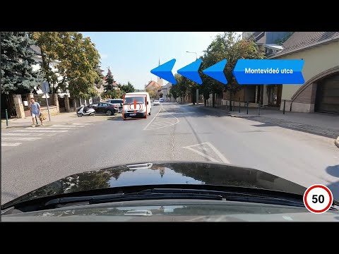
NNG IGO.AR fuses HD maps and 6D sensor data and pairs it with the latest in augmented reality visualization to create a solution that helps drivers learn and experience more of their environment while maximizing convenience and safety.
Delivering navigation
How these technologies are brought together into a single integrated solution is crucial. The solution must be able to combine maps and models with sensor data and guidance modules seamlessly to create accurate, real-time AR-powered navigation.
For instance, NNG’s iGO AR solution is already pioneering in this sector, fusing maps featuring enriched lane information with 6D modeling to offer the best of both worlds: An AR solution that provides unparalleled map accuracy combined with real-time route planning and visualization guidance. The latter can even detect ‘live’ objects such as other cars or even pedestrians, adjusting its guidance accordingly. Importantly, route planning, search and other navigation functions can all be carried out in-vehicle, or via the cloud, ensuring the drivers always has access to the data they need.
[IMAGE: Use NNG iGO AR image]
How everyone benefits
Importantly, NNG’s iGO AR solution is customizable to the OEM. Thanks to our offering’s modular setup, companies can layer their own UX/UI on top of iGO.AR to address any specific customization and branding needs. We also provide OEMs with the ability to scale iGO.AR with their own specific business operations as and when required.
Such versatility offers huge potential benefits whether it’s creating a safer, more convenient driving solution for road users or helping auto makers introduce innovative brand experiences that add genuine value to their products. While challenges still remain, pioneers like NNG are already demonstrating that – with the right approach and design ethos – the future of satellite navigation is already being transformed forever.
Would you like to know more?
Get in touch to learn more about our latest products and services or company news